Training ADAS with Automotive Radar Data
The development of modern advanced driver-assistance systems (ADAS) and autonomous transport directly depends on the vehicle's ability to continuously and flawlessly recognize its surrounding environment. Currently, most autopilot architectures rely on a synergy of optical cameras and LiDAR, which provide high resolution and precise geometry under ideal conditions. However, a real business case requires round-the-clock efficiency from commercial autonomous transport, where any downtime due to bad weather brings significant losses.
This is exactly where optical systems demonstrate their most significant vulnerability: cameras instantly go blind from direct sunlight, thick fog, or heavy rain, while LiDARs lose their ability to build a three-dimensional point cloud due to beam refraction in dust clouds, blizzards, or during dense snowfall. To overcome this technological dead end, the industry is shifting its focus to the integration of automotive radars. Operating in the millimeter wave frequency range, radio waves easily pass through water droplets, snow, and microparticles suspended in the air, ensuring a stable response under any weather conditions.
Quick Take
- Traditional cameras and LiDARs become ineffective in extreme conditions, which causes losses for commercial autonomous transport due to downtime.
- Millimeter-wave radars provide all-weather perception and are critically important for functions such as emergency braking, cruise control, and blind spot monitoring.
- Multimodal synchronization allows for the automatic transfer of understandable human visual markup onto the radar point cloud.
- The true reliability of an autopilot is tested in rare scenarios where radio waves reflect in the most chaotic manner.

Which ADAS Tasks Use Radar
Modern vehicles are becoming increasingly smart, and practically every safety function today counts on the assistance of radio waves. Thanks to all-weather perception, radar remains a reliable tool for situational control even when the driver and the vehicle's cameras see nothing due to a downpour or blizzard.
Here are the main driver-assistance systems that are technically incapable of operating without radar data:
- Adaptive Cruise Control. This system allows the car to automatically maintain a distance from the vehicle ahead. The radar continuously measures the distance and speed of the adjacent car so that the vehicle accelerates in time or smoothly brakes.
- Automatic Emergency Braking. If an obstacle suddenly appears ahead and the driver does not react, the radar gives a command for urgent braking. For this, the AI undergoes radar object detection training to flawlessly distinguish a real threat from an empty cardboard box on the road.
- Blind Spot Monitoring. Small radars installed in the corners of the rear bumper constantly "scan" the space to the side of the vehicle. They warn the driver with a light signal in the mirror if another car is hiding in the adjacent lane.
- Cross Traffic Alert. This function is indispensable when reversing out of a parking space when the view is blocked by adjacent vans. The radar spots cars approaching from the side long before the driver sees them in the mirror.
- Highway Assist. A comprehensive system that keeps the car in the center of the lane and controls a safe speed on the highway. Modern autopilots use the latest 4D radar annotation technologies for this, which see the road in maximum detail.
In order for all these functions to work without glitches, engineers feed gigabytes of examples to the artificial intelligence – a specialized automotive radar dataset. In it, every dot and signal reflection is carefully signed by hand thanks to painstaking radar point cloud labeling. This is the only way the machine learns to understand the difference between a stationary road sign and a pedestrian about to cross the road.
Why Radar Markup Has Become a Headache for AI Teams
Human Visual Perception
Unlike familiar photographs or videos, where the human eye instantly recognizes the silhouette of a child, the outlines of a truck, or the color of a traffic light, raw data from automotive radars is absolutely unreadable for an ordinary operator. If you open a standard radar log in a specialized program, the annotator will see only a chaotic, abstract cluster of multicolored dots, smudges, and flashes on the monitor screen. Without mathematical training, a person is physically incapable of understanding where a real pedestrian beginning to move is hiding in this digital noise, and where an ordinary concrete light pole is located.
This problem makes the classic approach to data marking completely pointless. Companies cannot simply hire thousands of low-skilled workers, seat them at computers, and ask them to outline "cars" on a radar map. Working with such data requires specialists who understand the nature of radio wave propagation and know how to interpret the amplitude and phase of the signal.
As a result, a paradox arises: radar is an ideal tool for a vehicle's artificial intelligence, but it is the hardest sensor for perception by a human annotator. Every attempt to parse a raw data array turns into an intellectual puzzle, slowing down the process of preparing high-quality training datasets.
The Problem of Specular Reflections and Noise
The physics of radar operation creates another serious challenge, which engineers call the effect of specular reflections and multipath signal propagation. Millimeter-wave radio waves tend to reflect off any metallic and dense surfaces just as light reflects off a mirror. When a car drives past a long iron fence, a metal guardrail on the highway, or even wet asphalt, the radar beam bounces off them several times before returning to the receiver.
Because of these multiple bounces, so-called phantom objects, or "ghosts", appear on the radar map. It seems to the system that another car is moving at high speed deep inside a wall or right in the middle of an empty adjacent lane. An ordinary annotator, seeing such a signal spike, is guaranteed to make a mistake: they will mark the phantom dot as a real threat, which will completely confuse the future neural network during its training.
Cleaning a radar log of such garbage requires colossal efforts. It is necessary to teach algorithms to ignore noise from bridges, tin cans on the road, and metal fences, but at the same time not to miss a real danger, for example, a car that has actually stopped around a turn. Every mistake at this stage costs too much, because an incorrectly marked phantom object will cause a real car to brake sharply and dangerously in the middle of a high-speed highway without an apparent reason in the future.
The Solution – Multimodal Synchronization
To emerge from this technological dead end, AI teams developed and implemented a method of multimodal synchronization known as sensor fusion. Instead of forcing a human to guess objects blindly by radar dots, engineers combine different types of data into a single coordinate system. While recording a dataset, the vehicle simultaneously captures the environment using ideal 4K cameras, laser LiDARs, and all-weather radars, with each frame synchronized down to the microsecond.
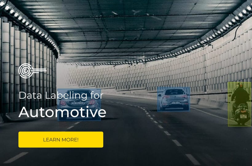
The markup process, according to this principle, looks like technological magic. The human annotator works in a convenient three-dimensional interface, where they see a clear and understandable video image from the vehicle's cameras. The operator easily finds a real car on the road and highlights it with a 3D bounding box – a three-dimensional frame. At that exact moment, specialized software automatically takes this box and, using precise mathematical transformation matrices, projects it onto the corresponding coordinates in the radar log.
Thanks to this approach, a cloud of radar dots that is "blind" to the human eye instantly receives its correct text marker and precise boundaries. Along with geometric frames, the system automatically pulls data about the speed and movement vector of the object. This approach allows for the creation of flawless training datasets, where the physical reliability of radio waves is combined with the visual accuracy of human sight, opening the way to training a truly safe autopilot.
Training in Critical Conditions
All-Weather Training
The main value of automotive radars lies in the fact that they see the world where other technologies fail. However, artificial intelligence does not receive this superpower automatically – it needs to be trained to recognize a complex environment through the prism of radio waves in the worst weather conditions. Collecting and marking datasets for specific weather scenarios is important for safety, as accidents occur in them most frequently:
- Heavy Rain and Thick Fog. Water droplets and suspension in the air absorb and refract light, making cameras blind and LiDARs helpless due to a high level of interference. Radar waves pass through the water shield, but the raw signal receives additional background noise that the AI must learn to ignore.
- Snowfall and Dirt on Sensors. When the front bumper and windshield of a car are covered with a layer of wet snow, ice, or road dirt, optical lenses completely lose their view. Radar radiation is capable of passing through moderate accumulations of dirt on a plastic cover, allowing the ADAS system to back up blocked sensors.
- Night and Direct Glare. A sharp change in lighting, such as driving against a low, blinding sun or being blinded by the high beams of an oncoming car, completely disorients cameras. For radio waves, the concept of light and darkness does not exist, so a radar dataset recorded at night ensures stable recognition of the highway geometry 24/7.
Road Anomalies and Rare Scenarios
The true value and uniqueness of commercial datasets are determined by the number of collected "edge cases." These are rare, non-standard, or complex situations on the road that usually cause standard algorithms to fail. Without meticulous markup of such anomalies, an autopilot-equipped car remains dangerous on real streets.
The industry highlights several crucial scenarios that require filigree marking:
- Motorcycles and Small Objects. Motorcyclists move fast, frequently maneuver between lanes, and their silhouette for radar is much smaller and weaker than that of a car. Training a model to notice such weak reflections, as well as reflections from luggage lost on the road or small animals, saves lives.
- Metal Structures and Tunnels. Entering a tunnel or driving under massive reinforced concrete bridges is a nightmare for radar algorithms. The metal and concrete around create thousands of chaotic reflections that merge into one continuous signal, so the AI is taught to distinguish the static iron of a tunnel from a car braking ahead.
- Multipath Reflections. This effect occurs when a radio wave reflects off a car, then hits a metal guardrail, and only after that returns to the radar. Because of this, the system may "see" a phantom car where there is none, and the annotator's task is to clearly indicate to the neural network where the real object is and where its radio echo is.
- Road Work Zones. Temporary plastic barriers, chaotically placed cones, and metal trailers with flashing arrows create a geometry that is difficult to interpret. Specialized datasets teach ADAS functions to recognize these labyrinths in time and smoothly change lanes before the dangerous section begins.
FAQ
What is the difference between conventional automotive radars and modern 4D radars in the context of data markup?
Classic radars capture only the distance, azimuth, and speed of an object, which makes them unable to determine its height and often causes them to "confuse" a bridge with a car underneath it. Modern 4D radars add a fourth dimension – the elevation angle, generating a much denser point cloud similar to a LiDAR one. For artificial intelligence, this means better quality object recognition, but the 4D radar annotation process requires significantly more time and computational resources for precise three-dimensional marking.
Is synthetic radar data used to train ADAS systems?
Yes, generating synthetic radar data is becoming a popular trend due to the complexity and high cost of collecting real accident scenarios in bad weather. Using specialized physical simulators, developers replicate the behavior of radio waves, taking into account the material of the objects and the effect of multipath propagation. However, they cannot completely replace real datasets, so synthetic data is used primarily for balancing the dataset and simulating rare accidents.
How does the material of an object affect the radar signal and its annotation?
Different materials have different radar cross-section reflection coefficients: metal returns a powerful signal, while plastic, carbon fiber, or the human body partially absorbs or scatters radio waves. During marking, annotators must take into account that a large plastic truck and a small iron motorcycle can yield a point cloud of identical brightness. The AI is taught to analyze the spatial structure and micro-movements of the object to avoid classification errors.
In what way does sensor fusion compensate for the difference in data refresh rates between a camera and a radar?
Cameras usually operate at a frequency of 30 or 60 frames per second, while a radar can update information with a different periodicity and delay. To synchronize them during the markup process, engineers apply the method of temporal interpolation and motion compensation based on microsecond timestamps.
How does contamination of the radar itself affect ADAS accuracy, and how is this marked?
Although radio waves pass through dirt, a very thick layer of wet snow or ice on the radio-transparent plastic of the bumper can weaken the signal and reduce the object detection range. Scenarios with partially blocked sensors are intentionally added to training datasets, marking them with reduced confidence tags. This is necessary to teach the vehicle's onboard computer to recognize signal degradation in time and warn the driver about the need to clean the bumper.
What tools or software do AI teams use to mark radar point clouds?
For marking radar data, classic 2D image editors are unsuitable, so specialized 3D markup platforms are used. These programs support working with three-dimensional spaces, allowing for the simultaneous display of the video stream, point cloud, and range-doppler maps in a single window. The main requirement for such software is automatic linear transformation and projection of 3D bounding boxes between different sensor modalities.