How Aerial Image Annotation Can Support Disaster Management
Artificial intelligence has transformed the way we process enormous quantities of data. While its applications are endless, our AI newsfeeds tend to focus on its commercial uses and how recent advances have redefined business as usual. But AI has the potential to make an impact in an unexpectedly humanitarian way.
When it comes to evaluating the impact of a natural disaster, a bird’s eye view of the impacted region is more than a nice-to-have — it’s critical to time-sensitive relief efforts. Without aerial imagery, verifying the useability of transportation corridors becomes much more difficult, delaying rescue operations that can’t afford to be delayed.
But gathering, annotating, and processing aerial data for disaster response doesn’t come without obstacles. Keep reading to find out how training data for aerial images can expedite relief efforts in the aftermath of the world’s most devastating natural disasters.
What Is Aerial Image Annotation?
In the hours, days, and weeks following a natural disaster, there’s no time to be wasted. The first step toward rescuing stranded civilians and protecting critical infrastructure is to locate and assess which areas have been hit the hardest. That’s where aerial view image annotation comes in.
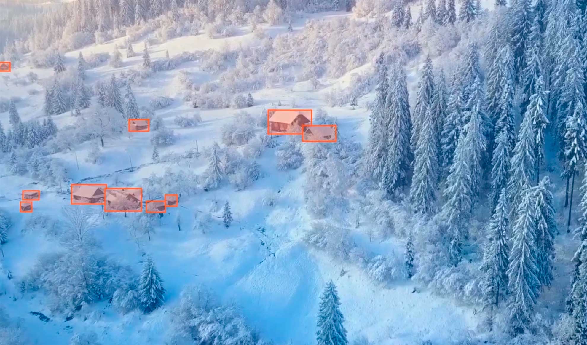
Aerial image annotation involves labeling satellite images or images taken by aircraft and UAVs. These images are then used to train computer vision models to analyze key features of a given environment.
Introducing Aerial Image Annotation for Disaster Management
Aerial imagery is incredibly valuable when it comes to assessing the condition of what’s down below. In recent years, satellite imagery has become increasingly available, heightening the demand for real-time flood and landslide detection.
When it comes to disaster management, aerial images can be labeled according to their portrayal of roads, buildings, ports, and more. These images can be used to determine real-time road conditions and the extent to which certain structures are compromised, allowing first responders to navigate safely and act quickly.
Aerial imagery is one of the most valuable resources for disaster management. Whether it’s an earthquake or a tsunami, an International Charter for Space and Major Disasters becomes activated by rescue organizations in the wake of a major natural disaster. This Charter was formed as the centerpiece of a collaboration between international space agencies, allowing for real-time disaster monitoring through satellite imagery.
Once the Charter is activated, satellite imagery can be accessed and analyzed to identify damaged areas that require immediate support. However, one of the primary obstacles to AI-mediated disaster management is the sheer volume of aerial imagery that needs to be annotated and the inability of volunteer data annotators to keep up with not just the volume, but the resolution required to make a measurable impact.
Aerial image annotation | Keymakr
Smart Disaster Management: Machine Learning for Aerial Image Labeling
On September 28, 2018, a 7.5-magnitude earthquake struck Indonesia and led to a tsunami in the city of Palu, laying waste to civilian lives and coastal infrastructure in what would be the deadliest and most damaging earthquake of 2018. Thousands died, and tens of thousands of buildings were destroyed or damaged.
Teams of volunteer data annotators organized by the government and other rescue organizations immediately began assessing the extent of damage and searching satellite imagery for rescue and evacuation routes. However, due to the volume of aerial photographs, these manual processes took days to complete.
Manual annotation of high-resolution satellite images can be slow and error-prone, slowing down relief efforts that must be prompt to be effective. That’s where machine learning comes in.
Machine learning has the potential to relieve such volunteer teams of the bulk of their image analysis workload, reducing the need for volunteers to manually — and painstakingly — digitize features on each image. In combination with robust machine learning algorithms, aerial image annotation has the potential to streamline disaster management and support prompt relief efforts.

Professional Data Annotation Services for Your Machine Learning Project
Machine learning has the potential to transform both industries and international relief efforts. But the performance of every machine learning project depends on the quality of its training data.
Are you interested in developing a machine learning application with real-world impact? Feed your algorithms the high-quality training data it craves by relying on professional data annotation services.
Keymakr provides pixel-perfect image and video annotations that meet your deadlines and fit your budget. Contact a team member to book your personalized demo today.