Data Annotation for Autonomous Drones: Navigating Airspace Safely
As autonomous drones become increasingly integrated into commercial, industrial, and defense operations, their ability to navigate complex airspace safely hinges on the quality of data used to train their systems. Data annotation and labeling key elements within aerial imagery, sensor data, and environmental recordings are essential. From identifying power lines and birds to classifying no-fly zones and mapping dynamic flight paths, accurate annotations enable drones to recognize and respond to obstacles in real time. Even the most advanced drone algorithms risk misinterpreting the environment without high-quality annotation, leading to safety hazards.
Key Takeaways
- Specialized labeling ensures compliance with FAA airspace regulations.
- Multi-format data processing supports both images and video streams.
- Industry-specific solutions enhance performance in agriculture and surveillance.
- Scalable workflows accommodate projects of any size or complexity.

Evolving Technology and Aerial Imagery
Modern drones are now equipped with high-resolution cameras, LiDAR scanners, and multispectral sensors, allowing them to perceive their surroundings with unprecedented detail. The quality of annotations must keep pace with these technological improvements to ensure that machine learning models can extract meaningful patterns.
Aerial imagery expands across industries, from infrastructure inspection and precision agriculture to wildfire detection and urban planning. In each case, drones must interpret vast and varied environments, making accurate annotation critical to operational success. For instance, identifying crop stress in a farm field or detecting micro-cracks on a wind turbine demands precise labeling at scale.
Impact on Model Training and Computer Vision
Clean, consistent, and context-rich annotations help machine learning models learn to detect and classify objects accurately across different altitudes, speeds, and terrains. In contrast, poor annotation introduces noise into training datasets, which can lead to misclassification, failed object detection, or unsafe flight decisions. Even minor inaccuracies in training data can cause significant performance issues for drones operating in safety-critical scenarios.
Drones operate in a three-dimensional space, requiring annotations for depth, motion, and scale from unique vantage points. Models must be trained to handle constantly shifting perspectives, varying sensor inputs, and real-time decision-making under uncertainty. This increases the importance of high-quality data pipelines and annotation tools designed specifically for aerial use.
Key Drone Data Annotation Services and Techniques
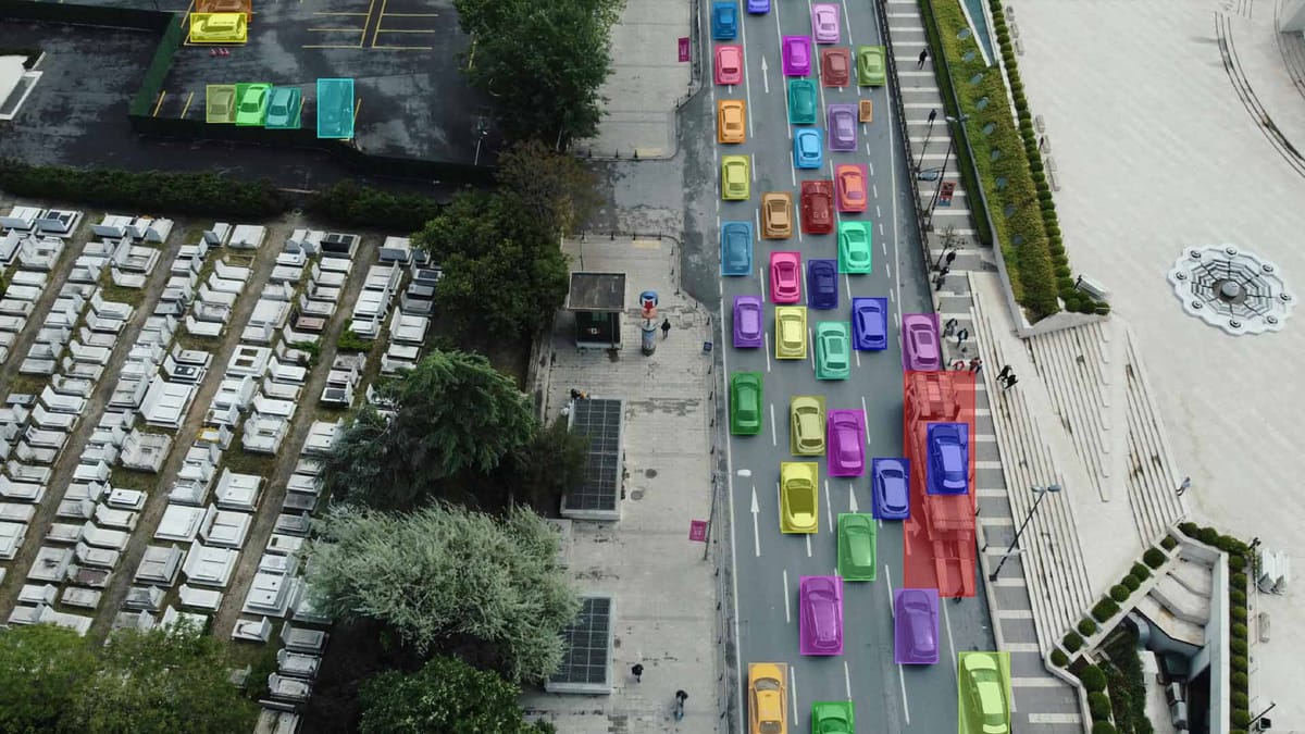
- Bounding Box Annotation. Used to identify and track objects such as buildings, vehicles, trees, or other airborne obstacles in aerial footage.
- Semantic Segmentation. Label every pixel in an image by category, helping drones accurately understand terrain types, water bodies, and road networks.
- 3D Point Cloud Annotation. Applied to LiDAR data, this technique enables accurate spatial understanding of elevation, depth, and object positioning.
- Polygon Annotation. Useful for outlining irregularly shaped objects like rooftops, farmlands, or infrastructure with more detail than bounding boxes allow.
- Keypoint and Landmark Annotation. Marks specific features such as drone landing zones, structural joints, or motion reference points for tracking and measurement.
- Object Tracking. Ensures continuity of object recognition across video frames, which is critical for monitoring moving targets like vehicles, people, or other drones.
- AI-Assisted Annotation and Quality Assurance. Combines automation with expert review to accelerate labeling without compromising accuracy.
Keymakr's aerial data annotation services combine multiple approaches to transform raw visual data into actionable intelligence for AI models.
Ensuring Data Integrity in Real-Time Systems
These systems depend on annotated training data to make immediate decisions while in flight, often with no room for error. If the data used to train or validate these models is inconsistent, mislabeled, or incomplete, it can lead to false detections, route deviations, or even collisions. Every annotation must reflect real-world conditions as closely as possible, mainly when drones operate in dynamic or high-risk environments.
Teams employ multi-step quality assurance processes that combine automated verification with manual review to uphold integrity. Redundant labeling, cross-validation across datasets, and scenario-based testing help identify and eliminate hidden inconsistencies. Real-time systems also require continuous data updates to adapt to new edge cases, environmental changes, or hardware updates.
Tailored Solutions for Diverse Operational Needs
Autonomous drones serve various industries, each with distinct operational demands that require tailored annotation solutions. In agriculture, drones need labeled data to detect crop stress, classify soil types, and monitor irrigation patterns. In contrast, drones for urban surveillance or infrastructure inspection must recognize detailed structural elements, moving vehicles, or human activity from high altitudes.
Keymakr develops custom workflows that align with each deployment's specific goals, sensor types, and environments. This might include integrating geospatial metadata, adjusting labeling granularity, or designing class hierarchies unique to an industry. Domain expertise becomes essential; annotators must understand what features matter most in a particular context and how those features appear from a drone's perspective. Whether highlighting heat loss on rooftops or mapping disaster zones, tailored annotation ensures that the resulting AI models are both relevant and highly performant.

Quality Assurance and Compliance in Data Annotation
Every mislabeled object, overlooked obstacle, or inconsistent tag can ripple through training pipelines, leading to faulty navigation behavior or mission failure. To prevent this, annotation teams implement multi-layered QA processes that include peer review, gold standard datasets, and automated consistency checks. These steps help maintain accuracy across large, complex datasets that may span different sensor types, regions, and operational conditions.
Alongside accuracy, regulatory compliance is an increasingly important aspect of data annotation for autonomous drones. Annotation workflows must respect these constraints, ensuring that sensitive information is redacted, GPS data is properly anonymized, and operational datasets meet legal standards for auditability. Compliance also extends to industry-specific certifications, such as those required in defense, infrastructure, or environmental monitoring.
Global Standards for Cross-Industry Trust
Global standards provide the common language that lets aerospace, agriculture, energy, and public-safety sectors trust the data pipelines behind autonomous drones. International frameworks such as ISO/IEC 25012 and ASTM F38 define how datasets must be documented, secured, and validated, ensuring that every stakeholder can audit the provenance of annotations without ambiguity. Because drones may collect imagery in one jurisdiction, be labeled in another, and inform decisions worldwide, these harmonized requirements safeguard privacy, airspace rules, and intellectual property across borders. They also establish baseline metrics for quality checks, from label accuracy to latency thresholds so that performance claims can be verified independently.
Adherence to these benchmarks is sustained through large-scale QA processes that combine automated validators with human oversight, creating a durable chain of evidence from raw capture to deployment. Providers implement mass annotation workflows that embed version control and continuous testing, allowing any partner, whether a defense contractor or a utility company, to confirm that datasets meet the same rigor.
Metrics-Driven Excellence
In autonomous drone development, metrics-driven excellence guides every stage of data annotation to maximize model performance and operational safety. Teams can objectively measure and improve annotation quality by defining clear, quantifiable benchmarks such as label accuracy, consistency rates, and annotation throughput. Continuous monitoring against these standards enables rapid feedback loops, allowing annotation workflows to adapt dynamically to new challenges or mission requirements.
Moreover, metrics-driven approaches support transparent reporting and accountability, essential for meeting regulatory and industry compliance. Performance dashboards, error heatmaps, and statistical quality reports provide stakeholders with actionable insights into annotation processes. Organizations can prioritize resources efficiently and justify investments in annotation technology by tying data quality directly to operational outcomes like obstacle avoidance success rates or flight path accuracy.
Scalable and Customized Annotation Solutions for Modern Drones
As drones generate massive volumes of diverse data from high-resolution video to multispectral and LiDAR sensors, annotation workflows must scale efficiently without sacrificing accuracy. Tailored approaches enable annotation teams to handle specific industry requirements, whether for precision agriculture, infrastructure inspection, or emergency response. Scalability ensures that drone operators can continuously update their AI models with fresh, relevant data to adapt to changing environments and mission goals.
Annotation schemas are designed to capture domain-specific features, such as crop diseases, structural defects, or hazardous zones. Integration with geospatial metadata and real-time sensor inputs enhances the relevance and usability of annotated data. Flexible workflows, from simple bounding boxes to 3D point clouds and thermal imaging, accommodate varying data formats and annotation complexities.
Team Expertise and Rapid Turnaround Capabilities
Experts with deep knowledge of drone technology, computer vision, and domain-specific applications understand the nuances of aerial data and can accurately label complex objects and scenarios. Their expertise ensures that annotations are precise and contextually relevant, which is vital for training robust AI models. Combining human insight with streamlined workflows and AI-assisted tools, teams can accelerate annotation while maintaining rigorous quality standards.
Collaboration between annotators, quality assurance specialists, and data scientists helps quickly identify and resolve bottlenecks. Additionally, agile communication channels allow for real-time feedback and adjustments, ensuring that evolving requirements are met without delays. This capability is critical in fast-paced industries where drones are deployed for time-sensitive missions, such as disaster response or surveillance.
Summary
High-quality, precise labeling of diverse aerial data types, including images, LiDAR, and thermal sensors, supports AI models in accurately recognizing obstacles, terrain, and dynamic environments. Tailored annotation techniques, rigorous quality assurance, and adherence to global standards ensure data integrity, regulatory compliance, and cross-industry trust. Scalable annotation solutions combined with expert teams enable rapid turnaround without sacrificing accuracy, allowing drones to adapt to varied operational needs. Robust data annotation underpins the reliable, intelligent, and safe operation of autonomous drone systems.
FAQ
Why is data annotation critical for autonomous drones?
Data annotation provides labeled information that trains AI models to recognize objects and environments, enabling drones to navigate safely and make accurate, real-time decisions.
What types of data are commonly annotated for drone AI?
Common data types include high-resolution images, LiDAR point clouds, thermal imagery, and multispectral data, each requiring specific annotation techniques.
How does annotation quality affect drone navigation?
High-quality annotation ensures accurate object detection and classification, reducing errors and risks during flight, while poor annotation can lead to misjudgments and safety hazards.
What annotation techniques are used for aerial drone data?
Techniques include bounding boxes, polygon and semantic segmentation, 3D point cloud labeling, object tracking, and geospatial tagging tailored to drone-specific requirements.
Why is quality assurance critical in drone data annotation?
QA processes prevent mislabeled or inconsistent data from degrading AI performance, ensuring the safety and reliability of autonomous drone operations.
How do global standards influence drone data annotation?
They establish standard data quality, security, and compliance criteria, fostering trust and enabling cross-industry collaboration and regulatory acceptance.
What challenges arise in annotating aerial imagery?
Challenges include variable lighting, altitude changes, motion blur, diverse environments, and capturing 3D spatial information accurately.
How do tailored annotation solutions benefit different drone applications?
Custom workflows and labeling schemes address the specific needs of industries like agriculture, infrastructure, or public safety, improving model relevance and effectiveness.
What role do expert annotation teams play?
Experts provide domain knowledge to handle complex aerial data accurately, ensuring contextually relevant labels and faster turnaround through optimized workflows.
Why is scalability important in drone data annotation?
Scalable solutions efficiently manage large volumes of diverse data, enabling continuous model updates and adaptation to evolving drone missions and environments.